
Page 44 - REALCOMM EDGE-Fall 2017-FINAL
P. 44
Intelligent BUILDINGS
Data Governance and Standards –
The Key to Intelligent Buildings
Dave Clute
VP, Intelligent Building Practice
Environmental Systems Design (ESD)
he importance of providing a well-defined data gover- Graphic data Within the built environment, graphic data typ-
nance strategy and adopting standards is more import- ically means 2D or 3D drawings, diagrams, charts, photographs,
T ant than ever in our quest to videos or images.
define, design and deliver intelligent “With the rapid growth of the Internet Tabular data A table is an
buildings. This topic has been the of Things (IoT), the need to define and arrangement of data in rows and
subject of panel discussions, pre- columns or possibly in a more com-
sentations and educational sessions adopt common data standards has plex structure. Tables appear in print
at Realcomm conferences for the gained even more importance.” media, handwritten notes, computer
past 15 years, but we still have much software and many other places.
work to do. During the design and construction of new buildings, it is
With the rapid growth of the Internet of Things (IoT), the often easier to implement a common set of data standards
need to define and adopt common data standards has because we can create spatial, graphic and tabular data
gained even more importance. The Open Standards starting with a clean slate. It is much more difficult
Consortium for Real Estate recently launched the with existing buildings, where we are inheriting
OSCRE Academy to help define what data gover- legacy definitions and interpretations. Either
nance means and how we can achieve a higher way, the path to achieving an Intelligent
level of understanding and adoption. Building, often referred to as the Intelligent
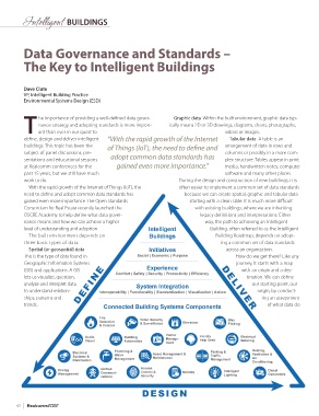
The built environment depends on Building Roadmap, depends on adopt-
three basic types of data: ing a common set of data standards
Spatial (or geospatial) data across an organization.
This is the type of data found in How do we get there? Like any
Geographic Information Systems journey, it starts with a map
(GIS) and applications. A GIS with an origin and a des-
lets us visualize, question, tination. We can define
analyze and interpret data our starting point, our
to understand relation- origin, by conduct-
ships, patterns and ing an assessment
trends. of what data do
42 Realcomm